How Miners Made Their Way to Montana in the 1860s
Country singer Charley Pride wasn’t born in Montana, but he lived in Helena and Great Falls and worked for the Anaconda Company, which certainly gives him status as a Montanan. What brought him to mind recently was a song he recorded called, “Railroad, Steamboat, River and Canal.”
Trying to figure out how miners came to Montana in the gold rush of the 1860s involved all four means of transportation.
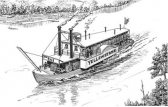
The influx of traders, miners, hopeful settlers and entrepreneurs who came up the Missouri River to Fort Benton is a fairly well-known story. We have a cluster of museums and the reconstructed fort to visit. In July, 1860, the steamboats Chippewa and Key West successfully navigated the winding, frequently shallow and snag-encumbered route from the East, connecting with the somewhat rudimentary Mullan Road to the West.
Less well-known was an optimistic plan to portage a steamboat past the Great Falls of the Missouri. Permanently located upstream, it was believed it would transport goods and miners nearly to Helena. Saner heads prevailed.
Even less known was a plan to reach the Blackfoot mines from Portland by steamboat. With the old imperialist rhetoric, “Westward the course of Empire” still echoing, we often think of the settlement of the inland West as an inexorable march from the East. It wasn’t that simple.
By 1855, ships carrying eager miners and goods for those eager miners to buy had been able to dock at Colon on the Atlantic side of the Isthmus of Panama. Passengers and cargo would take the Panama Rail Road to the Pacific side and travel by steamship up the West Coast. San Francisco and Astoria became key ports.
With the lure of ready markets and seemingly inexhaustible gold in Idaho, determined entrepreneurs soon located “steamers” along the Columbia and Snake as far as the vicinity of Lewiston. Travel was not first class. In 1866, a weary westbound Montanan described his trip. I’ll spare you the details of his supper the first night out — you may be reading this at breakfast time.
The next day, he rode along the Palouse to its confluence with the Snake, crossed it at Taksas Ferry and continued to Walla Walla. He noted with pleasure that, “henceforth cayuses are to be ignored and the more modern and rapid methods of travel adopted.” He wasn’t entirely free of horses, however, because there was still a 30 mile coach ride to Wallula, merely a depot for goods destined for the “upper country.”
The next morning started with a shrill whistle from the little steamer “Yakima,” and he began his journey downriver. About eight hours later, another shrill whistle announced their arrival of Celilo and the end of a journey of “a hundred and twenty miles of scenery devoid of interest.”
Here the passengers had to portage around boulder-strewn water which was “transformed into spray and foam.” A tiny train carried them along a track covered with great drifts of sand, “over trestle-work which creaked and groaned under its enormous burden and called to mind vivid pictures of railroad smash-ups.” Fifteen miles later, they arrived at the Dalles. “Here,” he noted, “the Columbia redeems her great reputation, for from hence to its mouth it presents the grandest and most varied scenery of any stream on our continent.”
There was one more railway portage, at the Upper Cascades, which featured a bridge some eighty feet in height. He rhapsodized over the views of Mounts Hood, St. Helens and Adams, but found little to admire in the Oregon Steam Navigation Company (OSNC) which “seemed to think that the scenery along their route is sufficient to feast one physically as well as mentally, for poorer fare was never placed before anyone.”
This passage was challenging, but steamboat travel was a money-maker for the OSNC and was carried upstream as far as Lewiston, Idaho. Locks and a canal were constructed which obviated the need for the Cascades portage. Railroad, steamboat, river and canal!
More challenging and apparently abandoned was plan to follow the Columbia to the Snake, “portage by wagon to Lake Pen d’Orielle (112 miles), from the lake to Horse Plains ‘most of the distance navigable’, (most?!) Horse Plains to Indian Agency on the Jocko Fork of the Bitter Root by wagon (25 miles). From the Agency to Hell Gate (40 miles), from Hell Gate to Blackfoot City (90 miles).”
It didn’t happen. Even if the route had been more practical, the Civil War rather got in the way and the completion of the transcontinental railroad in Utah in 1869 with spurs spreading out in all directions made the route unnecessary.
Travel may be easier now, but here’s a challenge for you: The rivers’ names often changed. Hand-drawn maps often erred. I’ve located three Clark Forks; the current Clark Fork has been called the Arrowstone, the Hell Gate and numerous earlier names by numerous tribes. The so-called Clark Fork of the Columbia flows into Lake Pen d’Orielle and flows out of it as part of the Pen d’Orielle River, so perhaps it should be called the Clark Fork of the Pen d’Orielle. Old maps show the Flathead River as the Clark Fork. And there’s even another Clark Fork on the other side of the Continental Divide.
The challenge? Straighten that out for me. Or perhaps I’ll just stick to I-90.
- By: Lyndel Meikle, Independent Record


